

Reliable January thaw; snow chance increasing Thursday
Go Deeper.
Create an account or log in to save stories.
Like this?
Thanks for liking this story! We have added it to a list of your favorite stories.
It may not quite be Old Faithful, but Minnesota's famed January thaw is surprisingly reliable.
A January thaw is defined as two or more consecutive days of high temperatures above 32 degrees. That happens in 93 percent of all years on record for the Twin Cities. In fact, a January thaw is more reliable than a white Christmas (72 percent) in the Twin Cities.
The last year without a January thaw was 2011. Last year's January thaw was one of the most prolonged on record and set several temperatures records, including an incredible four consecutive nights above freezing.

Mild start this week
Turn Up Your Support
MPR News helps you turn down the noise and build shared understanding. Turn up your support for this public resource and keep trusted journalism accessible to all.
It's amazing how good Sunday felt after two weeks in the deep freeze. After a high of 14 degrees Saturday, temperatures hit 32 degrees at Minneapolis-St. Paul International Airport Sunday night. Our Pacific breezes linger through Wednesday. It looks likely to me that temperatures will hit 40 in the Twin Cities this week. Subzero nights return by the end of the week.

Thursday snow chances growing
There are still some significant model differences (uncertainty), but the chance for snow is growing Thursday. Two big questions remain -- the precise storm track (location heavy snow band) and the temperature profile. (rain vs. snow)
The National Oceanic and Atmospheric Administration's Global Forecast System continues to show an elongated area of low pressure Thursday. That would imply a possible rain to ice to a few inches of snow scenario sweeping across Minnesota late Wednesday night into Thursday.

The European Centre for Medium-Range Weather Forecasts model favors a rain to sleet to snow scenario for the Twin Cities. That implies precip-type issues which can complicate (usually reduce) eventual snowfall totals. The going European Centre forecast would imply a couple sloppy inches for the Twin Cities.
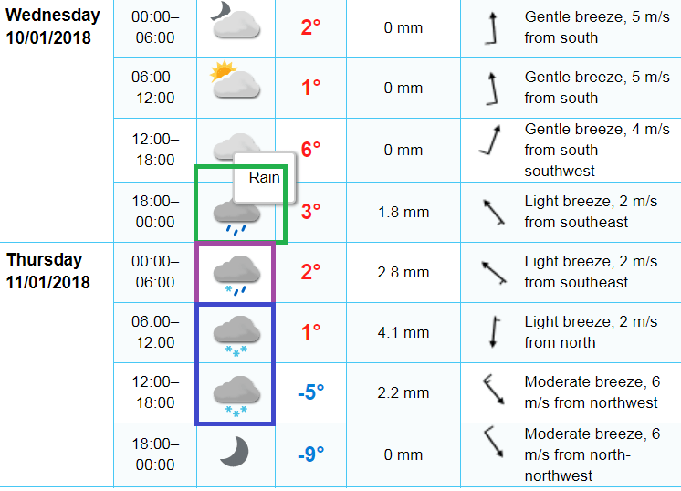
Either way the chances for a shovelful to plowable snow are growing Thursday. We'll refine the forecast into Wednesday, but factor snow into your plans for Thursday.
Twin Cities NWS to grade snow forecasts
Here's a new one for you. The Twin Cities National Weather Service office will grade it's snowfall forecasts this winter. The process is a bit complicated, but basically they will issue grades for the location of the 6-inch snowfall zone with winter storms.
Here are details from the Twin Cities National Weather Service.
For a winter storm to receive a grade, the following criteria must be met:
A warning is issued for 5 or more counties (due to snow);
Warning criteria is met for 5 or more counties (6+") without a warning issued; or,
Warning criteria is met for 2 or more counties (12+") without a warning issued.
Note: a grade is not assigned for events that have warnings issued solely due to impacts or to mixed precipitation events. This grading system is based largely on objective criteria which can be hard to maintain in complex scenarios. The goal is to have grades posted within 3 to 5 days of the event.
Elements graded:
6" contour spatial error
Magnitude of snow error
Onset timing error
Peak wind speed error
POD/FAR
Warning lead time
Impact messaging
Other criteria:
6” contour error will only be calculated if there is a large, continuous area of 6+ inches forecasted and observed. A forecast calling for 4 to 7 inches may include pockets of 6" bullseyes which make it difficult to objectively calculate distance between forecast amounts and actual amounts.
Some criteria may not be applicable with some storms, like 6” contour error or wind speed. Those won’t be included with the grade.
If a warning is not issued, the grade will be based on the forecast with 12 hours lead time.
Total possible points will be based on criteria being included. The final grade is on a scale from 0 to 10, rounded to the nearest tenth.
Grade = (actual points/possible points) X 10
Final note: local conditions and individual perceptions from the wide ranging types of our customers may vary from the objective grade calculated over a large area.
