Third wettest year-to-date on record; warmup starts Thursday
Go Deeper.
Create an account or log in to save stories.
Like this?
Thanks for liking this story! We have added it to a list of your favorite stories.
How wet has it been?
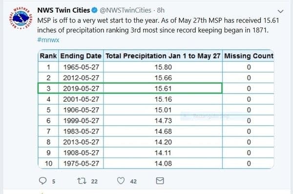
The 1.83 inches of rain at Minneapolis-St. Paul International Airport on Memorial Day brought our 2019 precipitation total (rain plus the water content of snow) to 15.61 inches. That's the third highest precipitation total from January 1 through May 27 in Twin Cities weather records:

It was a soggy Memorial Day for much of the southern half of Minnesota and most of western Wisconsin:
"Yesterday" refers to Monday in the tweet.
Turn Up Your Support
MPR News helps you turn down the noise and build shared understanding. Turn up your support for this public resource and keep trusted journalism accessible to all.
Planting is running late
Our cool and wet spring has delayed crop planting in many parts of Minnesota. Tuesday's Minnesota Crop Progress & Condition report from the USDA and the Minnesota Department of Agriculture states:
Cool damp weather led to 2.0 days suitable for fieldwork during the week ending May 26, 2019, according to USDA’s National Agricultural Statistics Service. Limited planting progress was made for all crops in Minnesota despite the soggy conditions.
Topsoil moisture supplies were rated 1 percent very short, 2 percent short, 44 percent adequate and 53 percent surplus. Subsoil moisture supplies were rated 0 percent very short, 2 percent short, 46 percent adequate and 52 percent surplus.
Sixty-six percent of Minnesota’s corn was planted, 8 days behind last year and 13 days behind the five-year average. Twenty-one percent of the corn crop had emerged, 2 weeks behind normal. Soybeans were 35 percent planted, 8 days behind last year and 2 weeks behind the average, while 3 percent of the soybean crop had emerged.
Over the past five years in Minnesota, an average of 93% of our corn and 77% of our soybeans have been planted by May 26:

Temperature trends
Most of Minnesota and western Wisconsin will see highs in the 70s Wednesday afternoon, but there'll be some 60s in far southern Minnesota. Twin Cities metro area highs are expected to be around 70.
High temperatures ramp up a bit in central and southern Minnesota on Thursday:

Twin Cities metro area highs are projected to reach the lower 80s on Friday, followed by lower 70s Saturday and mid 70s on Sunday.
Rain chances
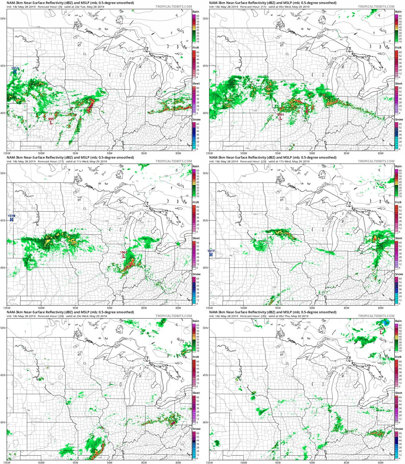
Far southern Minnesota could see some scattered showers and an isolated thunderstorm late Tuesday night. The best chance of scattered showers and thunderstorms on Wednesday will be in far southern Minnesota and parts of southwestern Wisconsin, but some scattered showers could drift as far north as the Twin Cities metro area at times.
The National Oceanic and Atmospheric Administration’s North American Mesoscale forecast model shows the potential rain pattern Tuesday evening through Wednesday evening:

The color chart to the right of the loop refers to the strength of the signal that returns to the radar, not to the amount of rain. It will rain in some areas that look dry in the NAM loop, but the loop illustrates the general rain pattern.
As always, updated weather information can be heard on the Minnesota Public Radio Network, and you’ll also see updated weather info on the MPR News live weather blog.
Rivers are rising
Recent rainy weather has caused river levels to rise again across much of southern Minnesota, and rivers have reached flood stage at many locations.
You can click on any location on the NWS Advanced Hydrologic Prediction Service (AHPS) site to get hydrographs of recent and forecast river levels. Some locations list levels in feet above sea level, others list levels in feet above a local reference point.
Here’s the Tuesday evening hydrograph for the Mississippi River at St. Paul:

You can see that the Mississippi River was hovering right around the boundary between minor and moderate flood stage Tuesday evening at the St. Paul location. It's expected to rise about another 12 inches at that location between Tuesday evening and late Friday.
The lower portions of many trees on the eastern side of Raspberry Island were underwater Tuesday evening:

There are flood warnings along some rivers in Minnesota. You can get flood warning updates by clicking on any green-shaded location on the National Weather Service Twin Cities website.
Here’s how the NWS map looked Tuesday evening:

Projected river levels are updated on a regular basis, so check back to the AHPS site and the National Weather Service point forecasts for the latest info on the rivers near you.
If you’d like to scroll through hydrographs along a certain river in central or southern Minnesota, check here.


