'Stratus quo': Cloudiest January on record in the Twin Cities
It's been cloudy 72 percent of the time this month.

Go Deeper.
Create an account or log in to save stories.
Like this?
Thanks for liking this story! We have added it to a list of your favorite stories.
It’s not your imagination, Minnesota. This has been the cloudiest January in your lifetime.
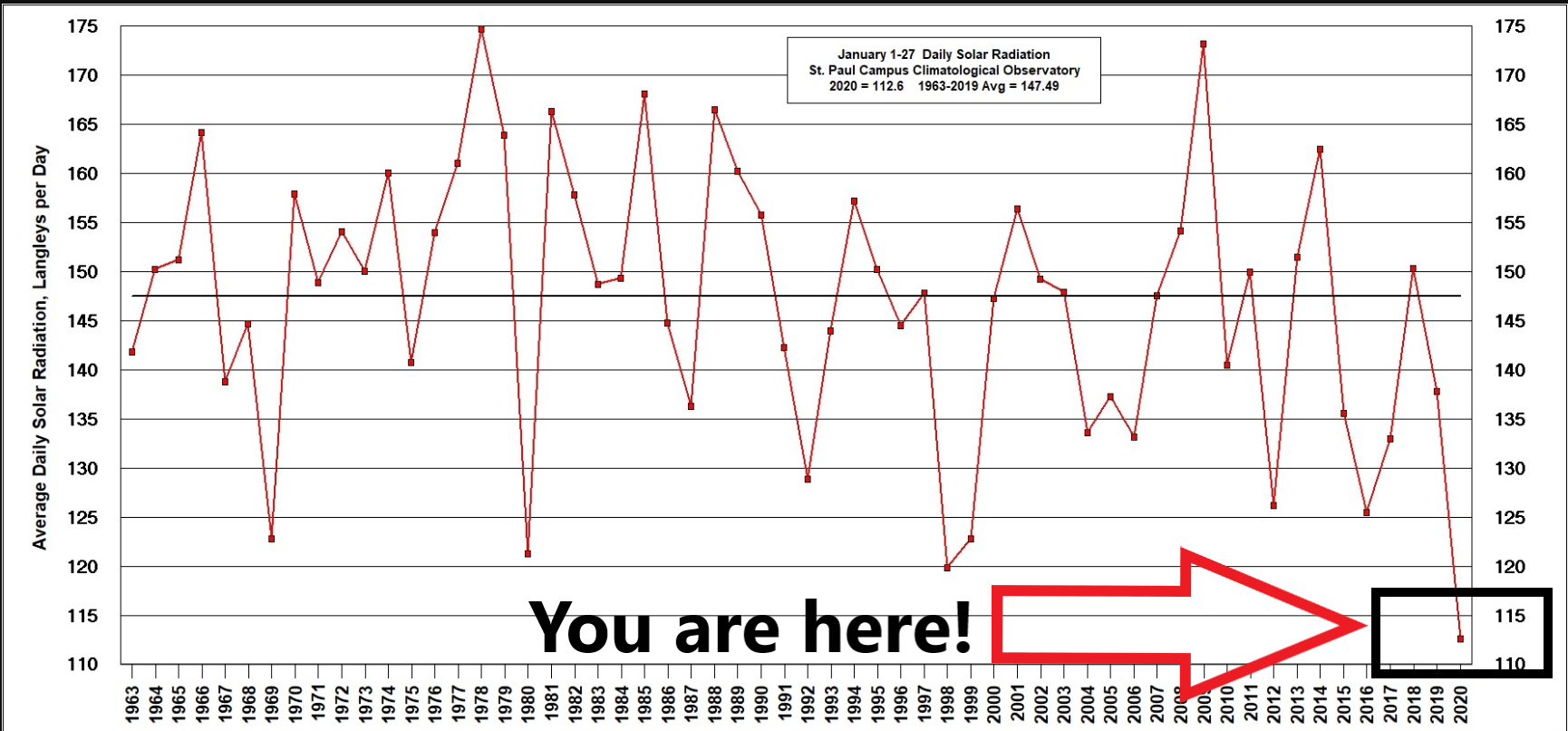
The University of Minnesota St. Paul Campus Observatory has recorded the lowest amount of solar radiation for a January since solar radiation records began in 1963.

So far though Jan. 27, January 2020 has had the least amount of solar radiation for a January since solar radiation records began at the U of M St. Paul Campus Climate Observatory in 1963.
The Twin Cities National Weather Service office calculates this month has been cloudy 72.4 percent of the time through Jan. 27. The 30-year average percentage of possible sunshine in January is 53 percent.
Weeklong gray streak
I saw some peeks of sun at the Weather Lab in Victoria, Minn., Sunday afternoon. But it’s been cloudy at the U of M St. Paul Campus Observatory site for seven straight days.
Turn Up Your Support
MPR News helps you turn down the noise and build shared understanding. Turn up your support for this public resource and keep trusted journalism accessible to all.
The last time that happened was in October and November 2018. Believe it or not, there have been even longer cloudy stretches in Minnesota.
The Minnesota DNR Climate Working Group has more historical perspective.
January 22-28, 2020 has been cloudy for seven consecutive days. The last time there was a stretch of seven straight days of completely cloudy conditions was in October 2018. There’s been longer stretches in the past.
The longest record of consecutive days with zero minutes of sunshine is fifteen days from October 30, 1972 to November 13, 1972. The 1972 streak is remarkable that on November 14 there was less than an hour of sunshine, then two more days of zero minutes of sunshine! The sunshine recorder was at the Twin Cities International Airport before June 1996 and moved to Chanhassen after that. The sunshine recorder has since been discontinued.
In 1991-1992 the skies were cloudy in the Twin Cities for fourteen days in a row from December 26, 1991 to January 8, 1992. The days were marked with clouds obscuring the tops of the skyscrapers in downtown Minneapolis, drizzle and of course, copious amounts of fog. The temperature for those fourteen days ranged between 27 and 37 degrees at the Twin Cities Airport, which is very unusual for winter. Back during that streak, the chairman of Fingerhut hired a plane to take their employees on a trip above the clouds to find the sun. An odd feature during this event was an "ice fog" that would freeze and thaw on power lines, shorting them out in west central Minnesota.
Since 1906, there have been two other long stretches of general cloud cover: Oct. 31 to Nov. 15, 1922 and a comparable stretch from Nov. 15 to 28, 1944. But those times were marked by at least a partial break in the clouds.
Weekend sunshine?
The next real probability for sunshine arrives Saturday afternoon and Sunday. That means our current cloudy streak will likely hit 11 days. Highs near 40 degrees with sunshine Sunday afternoon will be a dramatic change for many Minnesotans.

It should be noted that milder Pacific air masses in winter often bring more moisture and clouds. Colder arctic air masses are much drier and usually sunnier. So, the trade-off in winter for higher temperatures?
Less sun.


