June recap: A hot month across Minnesota
July is also off to a hot start, with more 80s and 90s
Go Deeper.
Create an account or log in to save stories.
Like this?
Thanks for liking this story! We have added it to a list of your favorite stories.
All of Minnesota had a hotter than average June, but precipitation was much more hit and miss. Now July is also starting off hot and humid, with above average temperatures into next week.
June’s weather highlights
The entire state of Minnesota ended up with above average temperatures during the month of June, many places by a few degrees.
For the Twin Cities, the temperatures over the 30 days of the month averaged 4 degrees above normal. Many places were even warmer, such as Mankato at 5 degrees above normal. Here is a break down of June temperatures in St. Cloud and the Twin Cities:

Precipitation for June was much more hit and miss (also shown in the comparison between St. Clouds and the Twin Cities). The Twin Cities got a few soaking rains, while northeast and west-central Minnesota saw areas of drought develop. Heavy rains the last two days of the month helped some of the dry areas, but provided little relief to northern Minnesota.
Turn Up Your Support
MPR News helps you turn down the noise and build shared understanding. Turn up your support for this public resource and keep trusted journalism accessible to all.

That includes Duluth, which is having one of its driest years to-date. Duluth saw below average precipitation 28 days during June, getting only .69 inches of rain versus the average 4.23 inches.

Wednesday evening and overnight
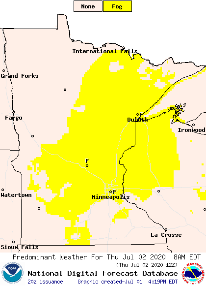
The cold front that brought more widespread rain to the western half of Minnesota late Tuesday into Wednesday morning is still moving across the state and producing a couple very isolated showers and storms Wednesday evening. Any activity that develops is likely to be in the very eastern edge of the state, especially the Arrowhead and southeastern Minnesota. Otherwise, skies remain dry overnight, but due to the high humidity and light winds, widespread fog is likely to develop by Thursday morning.

Extended forecast
The weather pattern turns quieter Thursday, with only isolated prospects for wet weather through Saturday. Then Sunday brings a higher chance for a few scattered showers and storms.
Under mostly sunny skies, the heat intensifies again Thursday, with most of the state back in the 90s. The entire next week remains well above average, with highs in the 80s and 90s across most of Minnesota, and the heat may even continue through mid-month.

Humidity levels also remain high, so the heat index will reach near and possibly surpass 100 degrees at times. Overnights also stay very mild, with lows in the 60s and 70s.
Programming note
You can hear my live weather updates on Minnesota Public Radio at 7:48 a.m. Monday through Friday morning.


