Drought severity increasing across the Upper Midwest
Signs of rain and cooler weather emerging next week

Go Deeper.
Create an account or log in to save stories.
Like this?
Thanks for liking this story! We have added it to a list of your favorite stories.
Drought conditions in the Upper Midwest are expanding and deepening this week.
The numbers from the latest U.S. Drought Monitor are not encouraging to farmers and water managers across the region.
Overall 27 percent of the Midwest region is now in drought status. But drought coverage is much higher in the northern half of the Midwest region where the percentage of moderate to severe drought is much higher in several states.
Drought conditions are even worse in the Dakotas. Over 70 percent of the Dakotas are in moderate or severe drought. And 67 percent of North Dakota is in extreme to exceptional drought.
Turn Up Your Support
MPR News helps you turn down the noise and build shared understanding. Turn up your support for this public resource and keep trusted journalism accessible to all.
Here is the state-by-state breakdown of drought coverage.
North Dakota: 99 percent
South Dakota: 79 percent
Michigan: 70 percent
Iowa: 57 percent
Minnesota: 46 percent
Wisconsin: 34 percent
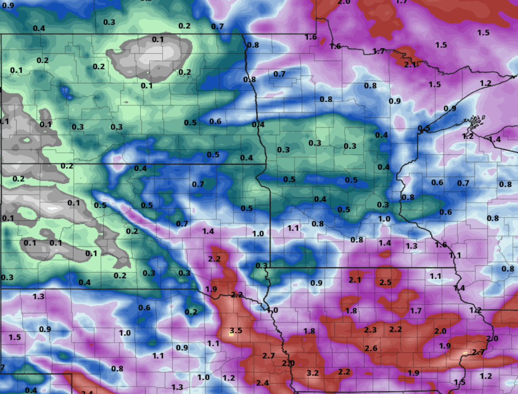
Much of the Upper Midwest has recorded less than half of average precipitation in the past 90 days. Rainfall has been abundant in the southern half of the Midwest.

Severe impacts growing fast
The impacts from the deepening drought in the region are growing fast. Here’s more detail on specific impacts across our region from the latest U.S. Drought Monitor.
Drought impacts are beginning to intensify in the Upper Midwest, including wildfire risk; water supply concerns for agriculture, municipalities and landscaping; and crop stress due to a lack of soil moisture.
Michigan and Minnesota have been dealing with an increased risk for wildfire for a couple of months now, and as a result, burn bans have been in place in some areas since early April. Just this past week, there were two wildfires in Superior National Forest in northern Minnesota.
Water supply concerns are impacting western and central Iowa, where drought has been an issue since summer 2020. Municipalities near Des Moines and Cedar Rapids are beginning to store and/or limit water use.
In Michigan, fruit growers irrigated in early June, which is the earliest those fruit growers could remember irrigating. However, the lack of rain led to lower disease and fungal pressure on fruits. The exception was powdery mildew which was more prevalent this year due to the dry spring.
While the drier weather was advantageous planting, crops are showing early season stress as a result of the dryness and warmer temperatures. Some farmers are worried that without rain, there will be a reduction in yield. Despite the issues, a majority of crops in the Upper Midwest are reported to be in fair, good or excellent condition, although there are some concerns over the condition of hay in Minnesota.
Chicago and surrounding areas have been feeling the impacts as well. Urban landscapes like trees, lawns, shrubs and plants are having a difficult time surviving unless adequately watered, particularly those that are newly planted.
Forecast: Cooler and wetter next week?
Overall forecasts for this week suggest more dry weather across most of our region this week. The exception is Thursday when a few forecast models suggest a chance for significant rain.

Next week appears to be trending cooler and potentially wetter across much of the Midwest. The National Oceanic and Atmospheric Administration’s eight-to-14 days temperature outlook favors cooler than average temperatures overall.

And the precipitation outlook suggests rainfall near to above average from Minnesota eastward.

Possible soaking rains next week
Forecast models suggest a possible widespread rainfall system sometime between late Sunday and Tuesday of next week.
The European model suggests abundant rainfall across Iowa, northern and southern Minnesota, but very little across much of central Minnesota.

The American GFS model suggests possible soaking rains across more of Minnesota and Wisconsin.

Most of the Midwest needs significant rainfall and cooler temperature to avoid plunging headlong into severe drought in the next two weeks. As of Monday, there is at least some hope for cooler and potentially wetter weather across much of the Upper Midwest next week.
Stay tuned.


