Drought now covers 75 percent of Minnesota; rain chances limited
Any expected rainfall this weekend is unlikely to turn the situation around

Go Deeper.
Create an account or log in to save stories.
Like this?
Thanks for liking this story! We have added it to a list of your favorite stories.
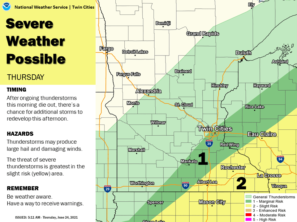
Recent rains have not been enough to turn around Minnesota’s worsening drought conditions. Despite chances for rain through the weekend, including a severe weather risk Thursday, the expected rainfall is unlikely to turn the situation around.
Minnesota had a very dry spring, especially May. June should be Minnesota’s wettest month, but it’s been dry and so much hotter than average that the heat has accelerated drought conditions.
For example, even with heavier rain on Sunday, the Twin Cities still has seen less that one-third of normal June rainfall through June 23, along with 11 days of 90 degree or above heat.
Thursday’s U.S. Drought Monitor report, with data compiled through Tuesday morning, shows dramatic changes just within the past week.
Turn Up Your Support
MPR News helps you turn down the noise and build shared understanding. Turn up your support for this public resource and keep trusted journalism accessible to all.

All of Minnesota is under at least “abnormally dry” conditions, which is no change. However, the area in moderate drought or higher blossomed from 56 to 75 percent, and severe drought jumped from 5 to 14 percent in the past week.
Drought now encompasses most of the Twin Cities, and northwestern and southern Minnesota are the areas where the severe drought is expanding.
Upcoming rain chances bring little chance of improving this worsening situation.
Thursday’s forecast
As of 9 a.m., the cold front associated with a storm system impacting Minnesota has made it through all but the southeastern corner of the state.
The cooler, drier air behind the front already brought northern Minnesota seasonable morning temperatures in the 50s and lower dew points. Central Minnesota started the day in the 60s, and the area ahead of the front is in the 70s and very muggy.
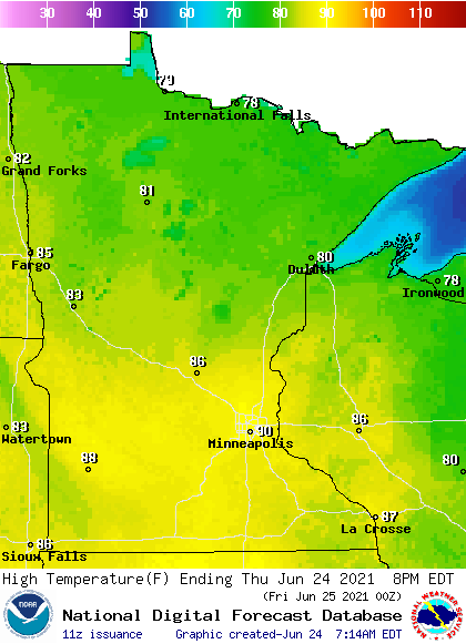
This temperature contrast will also be noticeable in the highs Thursday, with seasonable 70s and low 80s north, but a few 90s lingering in southern Minnesota.

Afternoon dew points, and thus the humidity, will be lower and in the 50s for most of Minnesota, while still stickier and in the 60s southeast.
With the front slowly making its way out of southeastern Minnesota Thursday, and becoming almost stationary, it provides the instability for showers and storms to develop, especially in the afternoon and evening.
Some storms may become severe, with damaging wind and large hail the primary risk.

Extended forecast
The cold front associated with the storm system finally clears far enough south by Friday to break the heat in southern Minnesota again, bringing highs in the 70s north and 80s south.
Highs over the weekend are expected to be in the low to mid-80s for most of Minnesota, which is a little above average, but still seasonable for late June. Dew points should also stay a little lower, mostly in the 50s, meaning less humid weather.
Even though slightly cooler air returns, much of the instability stays. Southern Minnesota in particular could still see a few showers or isolated storms into Friday. The weekend is also looking unsettled enough for occasional showers and storms around the state, but with plenty of dry breaks for outdoor activities too.

That should bring almost the entire state at least some rain, but for most places it would be less than one-half an inch and not enough to turn around the drought conditions.

Programming note
You can hear my live weather updates on Minnesota Public Radio at 7:49 a.m. Monday through Friday morning.


