

Wintry mess: Rain, ice, snow on Monday; more snow Tuesday night
Overall seasonable to slightly above normal temperatures

Go Deeper.
Create an account or log in to save stories.
Like this?
Thanks for liking this story! We have added it to a list of your favorite stories.
Updated 10:20 a.m.
Our latest system brings rain, ice and snow as warmer air sits over Minnesota. East-central Minnesota into western Wisconsin is seeing freezing rain make for icy conditions with slushy snow near Lake Superior and mainly rain south.
Wet, slushy Monday
Temperatures aloft early Monday were in the 40s while surface temperatures were right near freezing making for an icy mess. There were numerous reports of freezing rain Monday morning.

The weather balloon launch at the Twin Cities National Weather Service office in Chanhassen recorded a temperature of 43 degrees at about 3,000 feet above the ground; 31 one-hundredths (.31) of an inch of rainfall has accumulated since the rain began between 4 a.m. and 5 a.m. and much of that fell as a coating of ice.
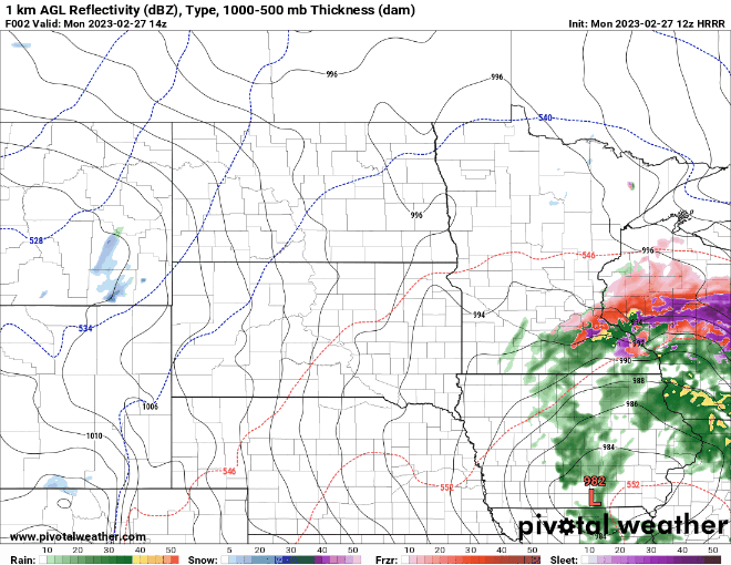
Ice accumulation is still possible mainly in western Wisconsin through the morning hours Monday. Temperatures will slowly climb above freezing making most of the moisture plain rain by midday and slushy snow farther north.
Turn Up Your Support
MPR News helps you turn down the noise and build shared understanding. Turn up your support for this public resource and keep trusted journalism accessible to all.
For areas a bit more north closer to Lake Superior, snowfall accumulations will add up into late Monday evening.

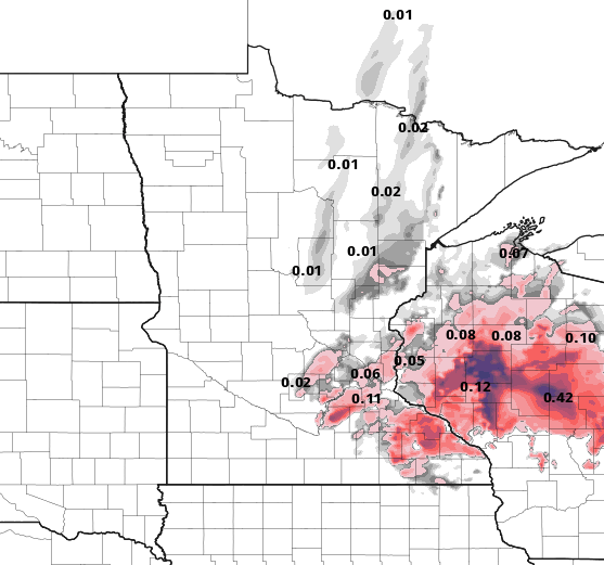
Precipitation for the Twin Cities and southern Minnesota will mainly fall as rain, and yet again it will be our third significant winter rainfall. Up to one-half to 1 inch of rain could fall.

Snow late Tuesday into Wednesday
The next system arrives late Tuesday into Wednesday. It will bring more precipitation, this time primarily in the form of snow across central Minnesota. Temperatures at the surface will be similar, in the 30s, but aloft it will be cold enough to produce snowfall.

The best chance of more significant accumulations look to be across a wide area of central Minnesota into western Wisconsin. After that, we’re in for a drier and quieter stretch with a quick blast of cooler temperatures Thursday.

