Rain-snow mix ahead for Minnesota Tuesday night
Mostly rain for Twin Cities, southern Minnesota; significant snow up north

Go Deeper.
Create an account or log in to save stories.
Like this?
Thanks for liking this story! We have added it to a list of your favorite stories.
As we move deeper into late March, our inbound low-pressure systems are coming in warmer. The system on the way now looks warm enough for mostly rain in the Twin Cities and southern Minnesota.
Rain-snow line through central Minnesota
The next low-pressure zone will track from central into northeastern Minnesota Tuesday night. That means the Twin Cities will finally be in the warm sector, the warmer southern side of the mid-latitude cyclone.
The rain-snow line will lay out through central Minnesota for this one. That means mostly wet snow for central and northern Minnesota.
The National Oceanic and Atmospheric Administration’s NAM 3 km model seems to have a pretty good handle on the rain, ice, and snow zones. The loop below runs between 6 p.m. Tuesday and 6 a.m. Wednesday:
Turn Up Your Support
MPR News helps you turn down the noise and build shared understanding. Turn up your support for this public resource and keep trusted journalism accessible to all.

Temperatures will rise into the 40s in southern Minnesota Tuesday afternoon.

Temperatures will remain above freezing in the Twin Cities and southern Minnesota Tuesday night. That means precipitation will be all rain and freezing on roads and other surfaces is not likely in the Twin Cities and southeast Minnesota.
It will be below freezing to the north, with snow and icy accumulations.

Significant snowfall north
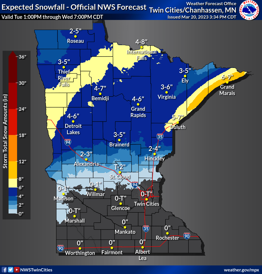
Several inches of snow will fall in the subfreezing air up north. You can see the latest statewide accumulation map at the top of this post.
Here’s a closer look at northeastern Minnesota. Snowfall totals greater than 6 inches look likely from Fargo, N.D., to Bemidji to International Falls, and along the North Shore.

The rest of the week looks quiet once we get through Wednesday.


