Ice, snow, rain to rake Minnesota Thursday into early Saturday
Update on advisories and warnings
Go Deeper.
Create an account or log in to save stories.
Like this?
Thanks for liking this story! We have added it to a list of your favorite stories.
A wintry mess is headed our way.
A low-pressure system will spread moisture into the Upper Midwest Thursday afternoon through Friday and Friday night.
Snow, freezing rain in first wave
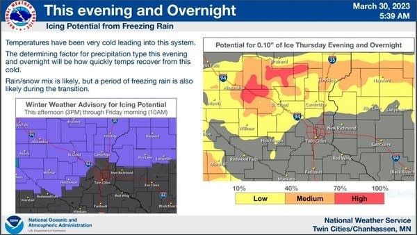
The first wave of precipitation is expected to begin as a mix of snow and freezing rain from southwestern Minnesota through much of central Minnesota and portions of northeastern Minnesota and northwestern Wisconsin, then transition to mainly snow in those same areas overnight into Friday.
The Twin Cities metro area could see some periods of rain showers Thursday afternoon through Thursday night, possible mixed with snowflakes at times.
Turn Up Your Support
MPR News helps you turn down the noise and build shared understanding. Turn up your support for this public resource and keep trusted journalism accessible to all.
The National Oceanic and Atmospheric Administration’s North American Mesoscale (NAM) forecast model shows the potential precipitation pattern from 1 p.m. Thursday to 10 a.m. Friday:

Winter weather advisories cover much of central Minnesota and parts of southwestern Minnesota from 3 p.m. Thursday to 10 a.m. Friday:

The winter weather advisory begins at 7 p.m. Thursday from Brainerd to Hinckley into northwestern Wisconsin.
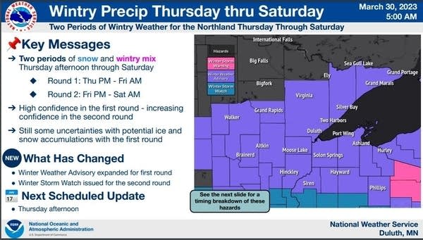
Winter weather advisories run from 7 p.m. Thursday to 7 a.m. Friday in northeastern Minnesota:

Most areas to the far north will see mainly snow, with a wintry mix that could include freezing rain at times from Duluth to Brainerd and Hinckley and over to Hayward, Wis.:

Rain, snow, maybe thunder in second wave
Round two of this storm system will initially bring rain to much of southern Minnesota on Friday, with a transition to snow Friday evening. Southern Minnesota and the Twin Cities metro area will also have a chance of thunderstorms Friday afternoon and evening.
Western and central Minnesota will see a wintry mix initially on Friday, with a quick changeover to mainly snow.
NOAA’s NAM forecast model shows the potential precipitation pattern from 11 a.m. Friday to 7 a.m. Saturday:

Several inches of snow are possible in many areas Friday evening and overnight into Saturday:

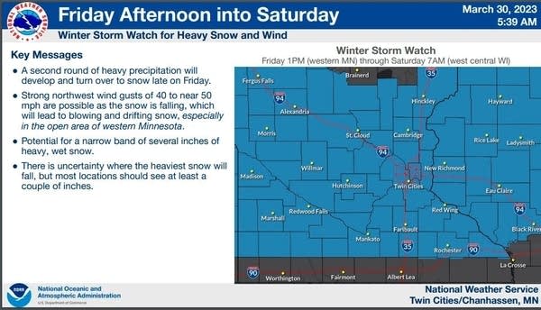
A winter storm watch covers much of central and southern Minnesota, including the Twin Cities, from either Friday afternoon or Friday evening into early Saturday:

Here are details of the winter storm watch that begins at 7 p.m. Friday in the Twin Cities metro area:
MNZ060>063-068>070-076>078-301800- /O.CON.KMPX.WS.A.0009.230401T0000Z-230401T1200Z/ Hennepin-Anoka-Ramsey-Washington-Carver-Scott-Dakota-Le Sueur- Rice-Goodhue- Including the cities of Minneapolis, Blaine, St Paul, Stillwater, Chanhassen, Chaska, Victoria, Shakopee, Hastings, Le Sueur, Faribault, and Red Wing 411 AM CDT Thu Mar 30 2023 ...WINTER STORM WATCH REMAINS IN EFFECT FROM FRIDAY EVENING THROUGH SATURDAY MORNING... * WHAT...Heavy snow possible. Total snow accumulations of 4 to 6 inches possible. Winds could gust as high as 45 mph. * WHERE...Portions of east central, south central and southeast Minnesota. * WHEN...From Friday evening through Saturday morning. * IMPACTS...Plan on slippery road conditions. Patchy blowing snow could significantly reduce visibility. Gusty winds could bring down tree branches. PRECAUTIONARY/PREPAREDNESS ACTIONS... Monitor the latest forecasts for updates on this situation.
The winter storm watch begins at 1 p.m. Friday in much of southwestern and central Minnesota.
You can find updated weather information for Minnesota and western Wisconsin on the MPR News network, and on the MPR News live weather blog.
Weekend temps
The average Twin Cities high temperature is 50 degrees on April 1. Metro area highs will be in the upper 30s this Saturday.
Most of Minnesota and western Wisconsin will have highs in the 30s on Saturday, with some 20s in northwestern Minnesota:

Sunday highs may range from 30s in northwestern Minnesota to 50s in the far southeast:

If we do receive several inches of fresh snow Friday night, I expect metro area highs to only reach the 40s on Sunday.
Programming note
You can hear my live weather updates on MPR News at 7:35 a.m., 9:35 a.m. and 4:39 p.m. Saturday and Sunday.


