

Northern lights potential Sunday night; Rivers are still rising in many areas
Temperatures rise the next few days
Go Deeper.
Create an account or log in to save stories.
Like this?
Thanks for liking this story! We have added it to a list of your favorite stories.
We’ll be dealing with some areas of clouds Sunday night, but you may be able to see a nice northern lights display when there are breaks in the cloud cover.
Here’s the Sunday night aurora forecast from the National Oceanic and Atmospheric Administration’s Space Weather Prediction Center:

Where cloud cover allows, the aurora may be visible from most locations in Minnesota and also as far south as Iowa. Viewing is best away from city lights.
You can see aurora updates on NOAA’s aurora dashboard.
Turn Up Your Support
MPR News helps you turn down the noise and build shared understanding. Turn up your support for this public resource and keep trusted journalism accessible to all.
Temperatures trend upward
Sunday’s high temp at Minneapolis-St. Paul International Airport was 45 degrees. That’s well shy of the Twin Cities average April 23 high of 60 degrees, but we’re headed in the right direction.
Many spots in the metro area will touch 50 degrees on Monday, with lower 50s in southern Minnesota and mainly 40s elsewhere:

Tuesday highs reach the 50s in roughly the southern half of Minnesota and into west-central Wisconsin, with 40s to the north:

Twin Cities metro area highs are projected to reach the lower 50s on Tuesday, followed by upper 50s Wednesday and then around 60 Thursday. Metro area highs then retreat to the lower 50s on Friday.
Shower chance?
Parts of Minnesota and western Wisconsin could see some scattered sprinkles or light snow showers Sunday evening.
Eastern Minnesota and western Wisconsin will have the chance of a light snow shower Monday morning, then western Wisconsin could see scattered sprinkles Monday afternoon with a sprinkle or light snow shower possible in northeastern Minnesota.
The best chance of rain arrives later this week, starting with scattered showers on Thursday and then periods of steadier rain on Friday.
Check forecast updates. You can find updated weather information for Minnesota and western Wisconsin on the MPR News network.
River levels

Rivers remain at flood stage in many parts of Minnesota and western Wisconsin, with rivers at major flood stage at several locations. Rivers will continue to rise in many locations the next few days.
You can check the river levels at various locations in northern Minnesota and northwestern Wisconsin here. This is how the linked map looked Sunday afternoon:

You can find info on river levels elsewhere in Minnesota and western Wisconsin here.
This is how the linked map looked Sunday afternoon:

You can zoom in on the linked map page and get detailed info on river levels at a specific location.
I should mention that river levels are measured in relation to the height above a local benchmark. In some locations, river levels are listed in feet above sea level.
You can find info on river levels in eastern North Dakota and northwestern Minnesota here. Here’s how the linked map looked Sunday afternoon:

Here’s the hydrograph of recent, current and forecast levels for the Mississippi River at St. Paul:

The Mississippi River has remains at major flood stage at St. Paul and it’s expected to rise slightly more than one foot between this evening and Thursday evening, reaching 18.8 feet.
Here are the results of various river levels at the St. Paul gauge:

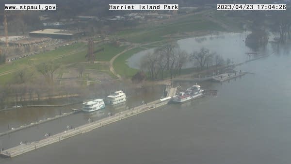
Here’s a pic of the Mississippi River floodwaters covering portions of Harriet Island Regional Park in St. Paul Sunday afternoon:
Here’s the area around the Clarence Wigington Pavilion at Harriet Island Regional Park Sunday afternoon:

The screen grabs were from St. Paul’s Mississippi River Camera page, which rotates among several different views of the river.
The Mississippi River is also at major flood stage at Hastings, Red Wing and Wabasha and it’s still rising at all three locations.
Here’s the hydrograph of recent, current and forecast levels for the St. Croix River at Stillwater, Minnesota:

The St. Croix River is at major flood stage and is forecast to rise slightly more than one-half of a foot between now and Tuesday evening, cresting around 89.7 feet..
Here are the results of various river levels at the Stillwater gauge:

Here are the historic St. Croix River crests at the Stillwater gauge:

Here’s the hydrograph of recent, current and forecast levels for the Red River at Fargo, North Dakota:

The Red River at Fargo crested just below major flood stage on Saturday and it’s expected to lower by about one foot between now and Tuesday evening.
Programming note
You can hear my live weather updates on MPR News at 7:35 a.m., 9:35 a.m. and 4:39 p.m. each Saturday and Sunday.
