Better air quality Wednesday; smoke may return Thursday
Dangerous air quality and closed airports in New York

Go Deeper.
Create an account or log in to save stories.
Like this?
Thanks for liking this story! We have added it to a list of your favorite stories.
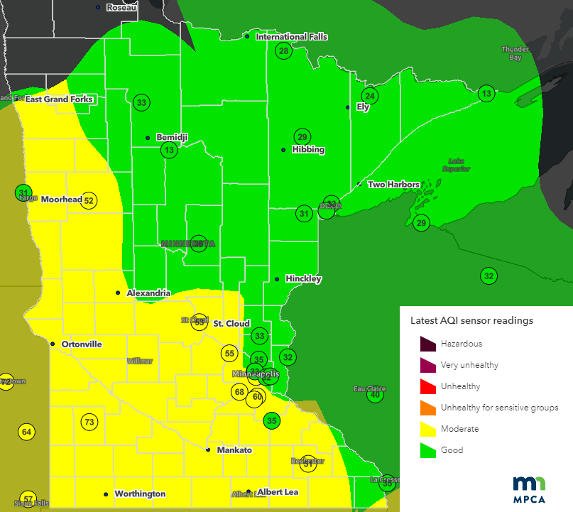
We’re breathing easier in Minnesota. Air quality readings on Wednesday have improved into the good to moderate range across the state. However, thick smoke plumes from massive wildfires in eastern Canada continue to spread across the northeastern United States.
The air quality in New York City was the worst for any major city on earth over the past 24 hours.
Check out this dangerous air quality index reading I found of 234 in the Bronx Wednesday.
The smoke plume is so thick it has forced ground stops at airports in New York and New Jersey Wednesday.
Turn Up Your Support
MPR News helps you turn down the noise and build shared understanding. Turn up your support for this public resource and keep trusted journalism accessible to all.
Thick wildfire smoke plumes will continue to blow south into the U.S. this week.
The National Oceanic and Atmospheric Administration’s Rapid Refresh smoke model indicates the back edge of the eastern plume may retrograde back into eastern Minnesota late Wednesday night into Thursday.

We may also see an increase in near-surface smoke here at ground level.

Based on those trends, the Minnesota Pollution Control Agency indicates they may issue another air quality alert for eastern Minnesota Thursday. Here’s the latest forecast discussion from MPCA:
Updated Wed, Jun 7, 2023
An area of widespread smoke from wildfires in Quebec will continue to linger across much of the state today. Winds will remain light and from the east. The weather pattern bringing airmasses from east to west will hold and bring another wave of smoke into the eastern part of the state beginning late this afternoon. The smoke will impact the eastern half of the state through tomorrow. The smoke may be heavy and another alert may be needed. We'll continue to monitor the forecast.
Spotty rain, comfortable temperatures
Our skies have been smoky and we need rain across most of Minnesota.
There will be a few scattered thundershowers favoring western Minnesota overnight into Thursday. I like the looks of NOAA’s North American Mesoscale 3 km model, which favors a cluster of cells drifting southward across western Minnesota overnight into Thursday.

Temperatures will be pleasant right through the upcoming weekend. Highs will be in the upper 70s and lower 80s across most of Minnesota for the next few days, and cooler by your favorite Great Lake.


