Thick wildfire smoke plume brings unhealthy air quality to Minnesota
Air quality should improve Thursday into Friday across Minnesota

Go Deeper.
Create an account or log in to save stories.
Like this?
Thanks for liking this story! We have added it to a list of your favorite stories.
Call it a smoke front. That’s what it looks like from space on weather satellites and here on the ground on air quality monitors.
You can see the leading edge of the smoke plume moving through the Twin Cities into southern Minnesota in the satellite image at the top of this post.
The air quality map Wednesday afternoon confirms the smoke has reached ground level across much of the state. Air quality readings are in the unhealthy-for-everyone (red) range across most of central Minnesota.
As of this post, the AQI index at St. Cloud was 188 ppm for fine particulate matter. AQI readings above 150 also appear at Fargo, N.D., Brainerd, and Duluth.
Turn Up Your Support
MPR News helps you turn down the noise and build shared understanding. Turn up your support for this public resource and keep trusted journalism accessible to all.

Air quality alert expanded
The air quality alert now includes all of Minnesota. It also includes most of western Wisconsin until noon Thursday.
Including the cities of Albert Lea, Alexandria, Apple Valley, Blaine, Bloomington, Brooklyn Park, Buffalo, Burnsville, Eagan, Eden Prairie, Farmington, Hastings, Mankato, Maple Grove, Minneapolis, Minnetonka, Northfield, Plymouth, Prior Lake, Ramsey, Rogers, Rosemount, Roseville, Shakopee, St. Cloud, St. Louis Park, St. Paul, Stillwater, Waconia, White Bear Lake, and Woodbury
1158 AM CDT Wed Jun 14 2023
...AIR QUALITY ALERT NOW IN EFFECT THROUGH 6 AM CDT THURSDAY...
* WHAT...The Minnesota Pollution Control Agency has expanded the Air Quality Alert for fine particle pollution. The Air Quality Index (AQI) is expected to reach the Red or Unhealthy category.
* WHERE...Central Minnesota.
* WHEN...Through 6 AM CDT Thursday.
* IMPACTS...Some members of the general public may experience health effects. Sensitive groups, such as people with lung disease (including asthma), heart disease, and children and older adults, may experience health effects.
* ADDITIONAL DETAILS...Smoke from Canadian wildfires has moved into Minnesota this morning. The smoke will continue slowly moving south during the day Wednesday and will approach the Minnesota river valley by the evening. Smoke will gradually clear Friday morning. In addition, sunny skies, warm temperatures, low humidity, and light winds will produce an environment for Volatile Organic Compounds (VOC) and Oxides of Nitrogen (NOx) to react in the air to produce elevated levels of ozone Wednesday afternoon. Ozone will be elevated across the Twin Cities and Rochester during the afternoon hours, but will decrease in the evening.
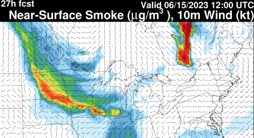
The National Oceanic and Atmospheric Administration’s Rapid Refresh smoke model shows cleaner air pushing into eastern Minnesota from the Great Lakes Thursday morning.
Here’s the forecast image for 8 a.m. Thursday:

So air quality should improve Thursday into Friday across Minnesota.
Stay tuned.


