Hot Monday; Thunderstorm chance in some areas Monday, in many areas on July Fourth
Update on severe weather potential
Go Deeper.
Create an account or log in to save stories.
Like this?
Thanks for liking this story! We have added it to a list of your favorite stories.
It’ll be a quiet Sunday afternoon in much of Minnesota and western Wisconsin.
Parts of northwestern Minnesota will see some scattered showers and thunderstorms at times Sunday afternoon and Sunday evening. Portions of west-central Minnesota and north-central Minnesota could also see a shower or thunderstorm.
The National Weather Service Storm Prediction Center shows a marginal risk of severe weather (shaded darker green) this Sunday and Sunday night in a portion of northwestern Minnesota:

Marginal risk means that an isolated severe thunderstorm is possible.
Turn Up Your Support
MPR News helps you turn down the noise and build shared understanding. Turn up your support for this public resource and keep trusted journalism accessible to all.
More of Minnesota and portions of Wisconsin will see some thunderstorms at times on Monday and Tuesday.
You can hear updated weather information for Minnesota and western Wisconsin on the MPR News network. You can find the latest radar here.
You can also check these National Weather Service sites for updated weather info: Twin Cities, Duluth, La Crosse, Wis., Sioux Falls and Grand Forks.
Thunderstorm chances increase on Monday and Tuesday
Convergence along a cool front plus increasing instability will lead to some areas of showers and thunderstorms on Monday, with the best thunderstorm chance initially in northern and western Minnesota.
The shower/t-storm chance expands to include most of Minnesota and parts of western Wisconsin Monday evening.
The NWS Storm Prediction Center shows a slight risk (yellow) of severe thunderstorms Monday afternoon and evening in west-central Minnesota:

A marginal risk (darker green) covers much of the remainder of Minnesota plus parts of western Wisconsin Monday afternoon and Monday night.
Slight risk means that scattered severe thunderstorms are possible, marginal risk indicates that an isolated severe thunderstorm is possible:

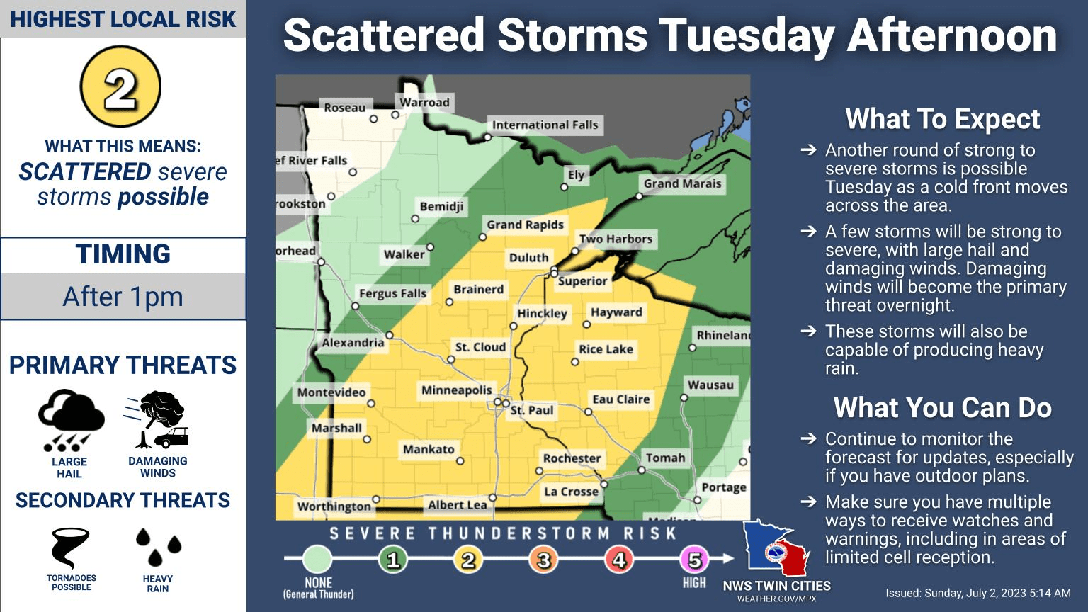
The risk of scattered severe thunderstorms (yellow) expands to cover most of southern and central Minnesota plus western Wisconsin and portions of northeastern Minnesota:

The National Oceanic and Atmospheric Administration’s Finite-Volumn Cubed Sphere (FV3) forecast model shows the potential rain pattern from 7 a.m. Tuesday to 7 p.m. Tuesday:

Some forecast models show a more patchy thunderstorm pattern, so check updates as we get closer to the Fourth of July. Make sure that you have a way to receive weather warnings.
Temperature trends
The average Twin Cities high temperature is 83 degrees on July 2. Metro area highs are expected to be around 90 degrees this Sunday.
Sunday highs will be well into the 80s across most of Minnesota and western Wisconsin, with a few spots in southern Minnesota and far northwestern Minnesota hitting 90. There will be some 70s up along the North Shore of Lake Superior.
Monday will be hot in central and southern Minnesota and parts of western Wisconsin, with highs in the low to mid 90s:

There will be mainly 80s elsewhere.
Tuesday highs range from 70s in northwestern Minnesota to lower 90s in the far southeast:

Twin Cities metro area highs are projected to be near 90 on July Fourth, followed by upper 70s Wednesday and Thursday then lower 80s Friday.
Weather nugget
The hottest Fourth of July in Twin Cities weather records was in 2012, with a high of 101 degrees. The coldest Twin Cities high temp on the Fourth of July was 58 degrees, in 1967.
Programming note
You can hear my live weather updates on MPR News at 7:35 a.m., 9:35 a.m. and 4:39 p.m. each Saturday and Sunday.


