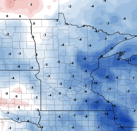
Below-normal temperatures Monday and Tuesday
A second cool front brings chance for showers Monday into Tuesday

Go Deeper.
Create an account or log in to save stories.
Like this?
Thanks for liking this story! We have added it to a list of your favorite stories.
Cool air is in place with a second reinforcing shot of cool air touching off spotty showers north Monday and south Tuesday. Temperatures will rebound to above-normal levels late in the week.
Cool front brings spotty showers, cool temps
Monday will see below-normal high temperatures in the upper 50s to low 60s north and low 70s in southern Minnesota. Normal highs range from the upper 60s in far northern Minnesota to mid-70s south.

Another cool front will touch off spotty showers late in the day in northern Minnesota with increased cloud cover. That chance of spotty showers then moves south Tuesday.

Tuesday’s highs will be only in the 50s and 60s, even several degrees more below normal.

With clearing skies Tuesday night, the stage is set for the coolest overnight Tuesday night into early Wednesday of this season potentially. We’ll have widespread 30s and patchy frost north and potentially the first 40s in the Twin Cities urban core.

We’re then in for a sunny stretch of days Wednesday into the weekend overall with temperatures modifying to above-normal readings again late week.
Turn Up Your Support
MPR News helps you turn down the noise and build shared understanding. Turn up your support for this public resource and keep trusted journalism accessible to all.
Dear reader,
The trustworthy and factual news you find here at MPR News relies on the generosity of readers like you.
Your donation ensures that our journalism remains available to all, connecting communities and facilitating better conversations for everyone.
Will you make a gift today to help keep this trusted new source accessible to all?


