Check out Wednesday morning's coldest temps; sun, warmth just ahead
Temperatures back above normal Thursday

Go Deeper.
Create an account or log in to save stories.
Like this?
Thanks for liking this story! We have added it to a list of your favorite stories.
It was a chilly start with widespread areas of frost in northeast Minnesota and our first 40s in the Twin Cities. Look for sunny skies Wednesday and warmer temps Thursday.
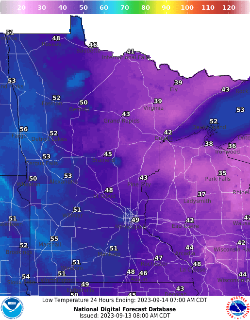
For most, the coldest morning since May
It was the coldest morning since mid to late May for most places in eastern Minnesota. In fact, we had some of the coldest temperatures in most of southern Canada and the contiguous United States thanks to a cool Canadian high-pressure area.

The official low at Minneapolis-St. Paul airport dipped to 47 degrees, the coolest since May 20, ending our streak of consecutive nights at or above 50 degrees. We had 116 consecutive nights at or above that threshold, a 29-percent increase from the normal 90 days.

Of course, the coldest readings were in northeastern Minnesota with Hibbing coming in at a low early Wednesday of 27 degrees.
Turn Up Your Support
MPR News helps you turn down the noise and build shared understanding. Turn up your support for this public resource and keep trusted journalism accessible to all.
Several other places, including Orr, Crane Lake, and Cook also dipped into the upper 20s. Locations that reached freezing or colder include Ely, Embarrass, International Falls, and Moose Lake.
Temperatures as far south as St. Cloud dipped to 35 degrees. Lake Elmo, east of St. Paul, reached 36 degrees.
Sunshine with a warming trend
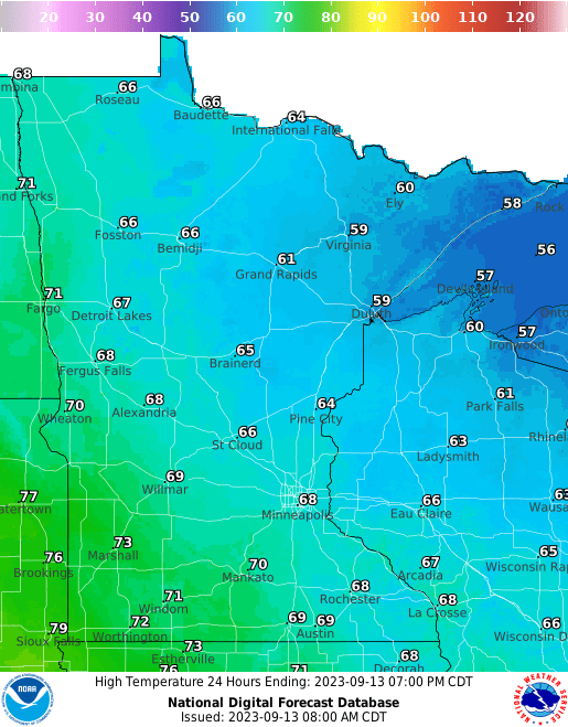
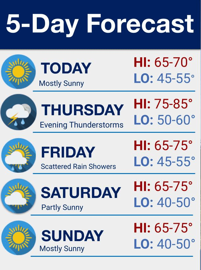
Sunny skies will warm us up Wednesday afternoon after a chilly start. Highs will be mainly in the 60s with some 70s in southwestern Minnesota.

Wednesday night won’t be as chilly but there will still be widespread 30s in northeastern Minnesota.

Temperatures really climb Thursday with summerlike readings returning to southern Minnesota. We’ll see highs in the 80s south to low 70s north with partly cloudy skies.

Next showers chance late Thursday into Friday
A slowly moving frontal boundary will touch off some showers and thunder late in the day Thursday in far western Minnesota.
That front will slowly move across Minnesota through Thursday night into Friday bringing increased cloud cover and at least a few showers and thunderstorms.

Unfortunately, it doesn’t look like a widespread, soaking rainfall. Most of us will see under one-quarter inch but portions of northwestern Minnesota might see some slightly more significant rainfall.

We clear out for the weekend making for a very pleasant Saturday and Sunday. Highs will be in the 70s south and 60s north with plenty of sun and mainly dry conditions.

Dear reader,
Political debates with family or friends can get heated. But what if there was a way to handle them better?
You can learn how to have civil political conversations with our new e-book!
Download our free e-book, Talking Sense: Have Hard Political Conversations, Better, and learn how to talk without the tension.


