

Weekend soaking rainfall chances increasing; severe risk Saturday
Forecast models shifting heavier rainfall toward the Twin Cities area

Go Deeper.
Create an account or log in to save stories.
Like this?
Thanks for liking this story! We have added it to a list of your favorite stories.
There’s good news in the overnight and midday Friday forecast model runs for those who want more rain. Our inbound weekend storm system is shifting to the east.
That means chances have increased for significant rainfall in the worst of the drought zone. That includes the Twin Cities area.
The National Oceanic and Atmospheric Administration’s Global Forecast System model paints the overall picture. Watch on the map below as bands of rain spin around the inbound low-pressure storm this weekend.

Slight severe risk
Saturday’s inbound weather system packs enough moisture and energy to produce a few strong to severe storm cells.
Turn Up Your Support
MPR News helps you turn down the noise and build shared understanding. Turn up your support for this public resource and keep trusted journalism accessible to all.
NOAA’s Storm Prediction Center paints a slight risk for severe storms in southwestern Minnesota, with a marginal risk extending eastward into the greater Twin Cities area.
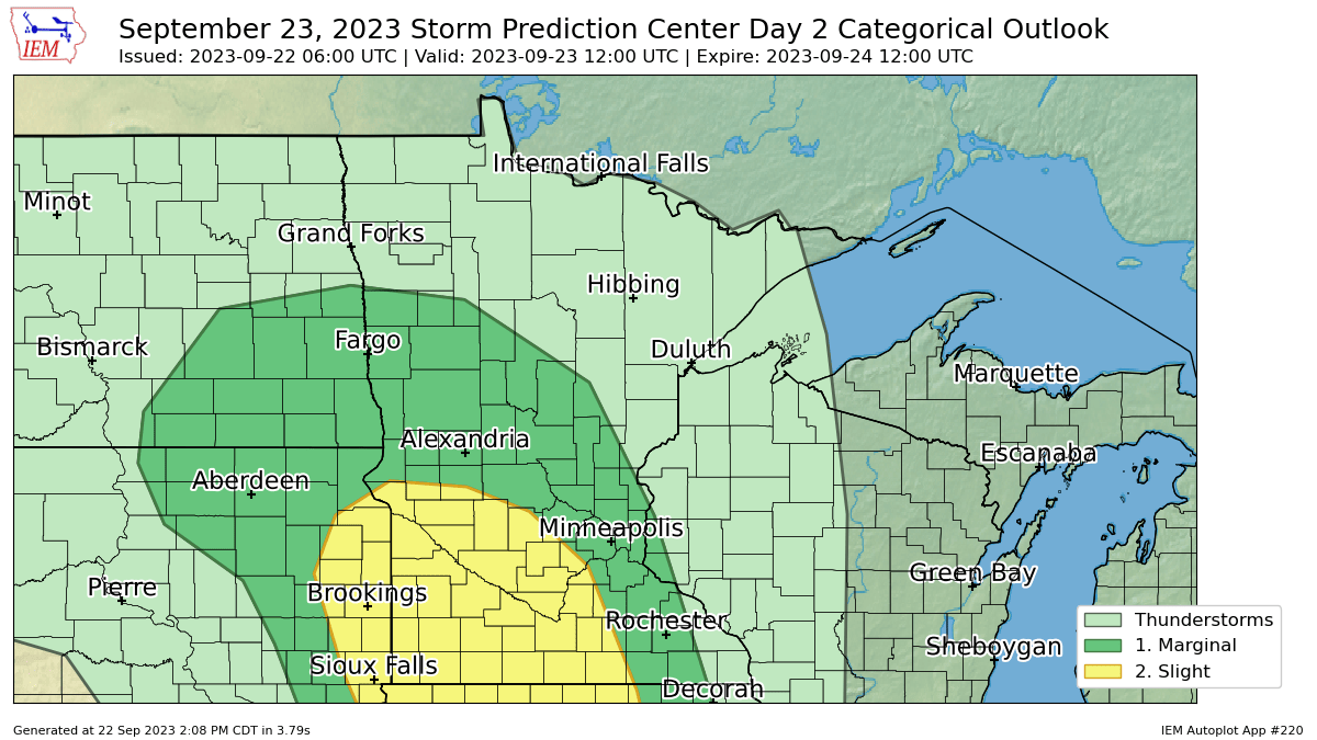
NOAA’s FV3 model paints spotty cells around early Saturday afternoon. Then a cluster of stronger cells looks likely to develop along the advancing frontal boundary Saturday afternoon in southwestern Minnesota and move eastward toward the Twin Cities by Saturday evening.
Forecast models suggest storms that could be severe in southwestern Minnesota Saturday afternoon but will likely fade some in intensity as they approach the Twin Cities.
The forecast model loop below runs between 1 p.m. and 10 p.m. on Saturday.

Rainfall totals
Compared to Thursday’s forecasts, the overnight and Friday midday forecast model runs show encouraging trends for higher rainfall totals in the Twin Cities and eastern Minnesota.
Several models now crank out multi-inch rainfall this weekend in or near the greater Twin Cities area.
The European Centre for Medium-Range Weather Forecasts model cranks out multi-inch rainfall potential in eastern Minnesota, including the Twin Cities area, through Monday.
Here’s NOAA’s Global Forecast System model:
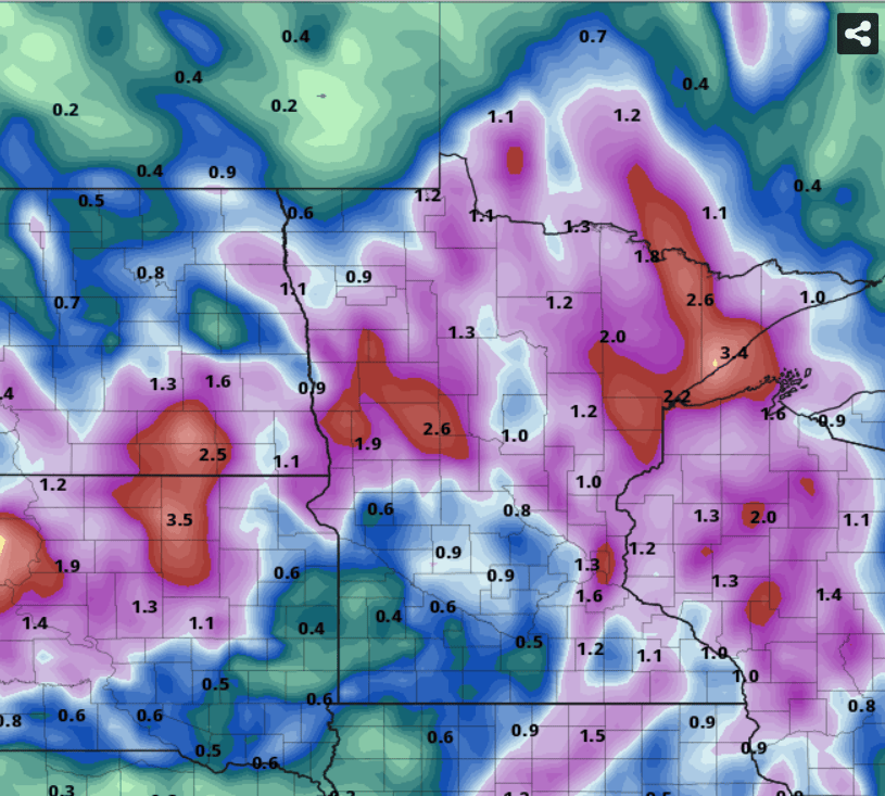
And the Canadian model is also aggressive with more than 2-inch rainfall potential around the Twin Cities.

Friday’s forecast model runs are looking much better for a good soaking rainfall for most of Minnesota including the greater Twin Cities area this weekend. Hopefully lawns, fields, ponds, and trees will get beneficial rainfall this weekend.
Stay tuned.
Dear reader,
Political debates with family or friends can get heated. But what if there was a way to handle them better?
You can learn how to have civil political conversations with our new e-book!
Download our free e-book, Talking Sense: Have Hard Political Conversations, Better, and learn how to talk without the tension.
