

Weekend weather: Cold; flakes at times Saturday afternoon and evening
Winter weather advisory Thursday night for NW Minnesota
Go Deeper.
Create an account or log in to save stories.
Like this?
Thanks for liking this story! We have added it to a list of your favorite stories.
I’ll dive into our weekend forecast details after this update on the Thursday snow hitting northwestern Minnesota.

Portions of far northwestern Minnesota are seeing snow or a rain-snow mix at midday Thursday. The snow area will expand a bit with several inches of accumulation by late Thursday night in parts of northwestern Minnesota and across much of North Dakota.
Here is the snow potential into Friday:

Winter weather advisories continue through 7 a.m. Friday for portions of northwestern Minnesota with winter storm warnings in much of North Dakota:
Turn Up Your Support
MPR News helps you turn down the noise and build shared understanding. Turn up your support for this public resource and keep trusted journalism accessible to all.
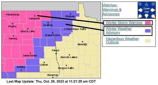
Here are details of the winter weather advisory in northwestern Minnesota:
URGENT - WINTER WEATHER MESSAGE National Weather Service Grand Forks ND Issued by National Weather Service Duluth MN 920 AM CDT Thu Oct 26 2023 MNZ001-004-005-007-008-013-014-NDZ016-027>030-038-271200- /O.EXT.KFGF.WW.Y.0025.000000T0000Z-231027T1200Z/ West Polk-Kittson-Roseau-West Marshall-East Marshall-Pennington- Red Lake-Eastern Walsh-Grand Forks-Griggs-Steele-Traill-Barnes- Including the cities of Crookston, East Grand Forks, Hallock, Karlstad, Lancaster, Roseau, Warroad, Greenbush, Warren, Stephen, Argyle, Newfolden, Middle River, Grygla, Thief River Falls, Red Lake Falls, Grafton, Park River, Grand Forks, Cooperstown, Finley, Hope, Mayville, Hillsboro, Hatton, Portland, and Valley City 920 AM CDT Thu Oct 26 2023 ...WINTER WEATHER ADVISORY NOW IN EFFECT UNTIL 7 AM CDT FRIDAY... * WHAT...Snow, at times mixed with rain. Additional snow accumulations of 3 to 6 inches. Winds gusting as high as 35 mph. The greatest accumulations will be this evening and tonight. * WHERE...Portions of northwest Minnesota and northeast and southeast North Dakota. * WHEN...Until 7 AM CDT Friday. * IMPACTS...Travel could be very difficult. Areas of blowing snow could significantly reduce visibility. The hazardous conditions could impact the morning or evening commute. PRECAUTIONARY/PREPAREDNESS ACTIONS... Slow down and use caution while traveling. The latest road conditions for North Dakota can be found at travel.dot.nd.gov and for Minnesota at 511mn.org, or by calling 5 1 1 in either state.
You can hear updated weather information for Minnesota and western Wisconsin on the MPR News network. Also check out the MPR News display of National Weather Service radar.
Weekend snow chance
Periods of snow are possible Saturday afternoon and evening across southern Minnesota, the Twin Cities metro area and parts of Wisconsin. The snow could begin Saturday morning in far southwestern Minnesota.
The National Oceanic and Atmospheric Administration’s North American Mesoscale forecast model shows the potential precipitation pattern from noon Saturday to 7 p.m. Saturday:

Periods of snow will continue into Saturday evening in the same areas that see Saturday afternoon snowfall.
Snow accumulation amounts of 1 inch or more are possible in southwestern and south-central Minnesota, with a coating to less than 1 inch in the Twin Cities metro area. Forecast snow amounts will be fine-tuned before Saturday.
This is the time of year that we can see snow accumulations melt fairly quickly. Check forecast updates
Cold weekend
The average Twin Cities high temperature is 52 degrees on Oct. 28. Saturday highs in the metro area and much of Minnesota will be in the 30s:

Far northwestern Minnesota could see highs in the 20s.
Sunday highs temps will be in the 20s across much of northern Minnesota, with 30s elsewhere:

This weekend will feel more like late November than late October.
Drought update
The U.S. Drought Monitor report released Thursday shows little change in drought conditions across Minnesota:

The rainfall cutoff for the drought map was 7 a.m. Tuesday, and several areas have seen substantial rainfall since then.
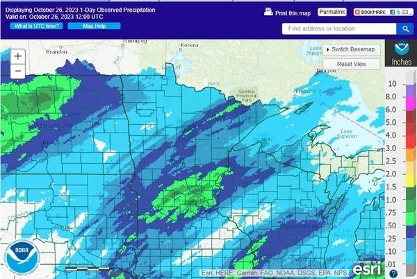
Here is the rainfall map from 7 a.m. Tuesday to 7 a.m. Wednesday:

Here is the rainfall map from 7 a.m. Wednesday to 7 a.m. Thursday:
Next week’s drought report will include the rainfall that we’ve seen since 7 a.m. Tuesday.
Programming note
You can hear my live weather updates on MPR News at 7:35 a.m., 9:35 a.m. and 4:39 p.m. each Saturday and Sunday.
Dear reader,
Political debates with family or friends can get heated. But what if there was a way to handle them better?
You can learn how to have civil political conversations with our new e-book!
Download our free e-book, Talking Sense: Have Hard Political Conversations, Better, and learn how to talk without the tension.
