

Valentine's Day forecast is more thorns than roses
Two rounds of snow for the weekend followed by bitterly cold temperatures

Go Deeper.
Create an account or log in to save stories.
Like this?
Thanks for liking this story! We have added it to a list of your favorite stories.
This Valentine’s Day weekend we will feel the frosty embrace of winter as arctic air moves in by Sunday night. Expect snowfall chances through Friday afternoon and evening, with another possibility of light snow Saturday night.
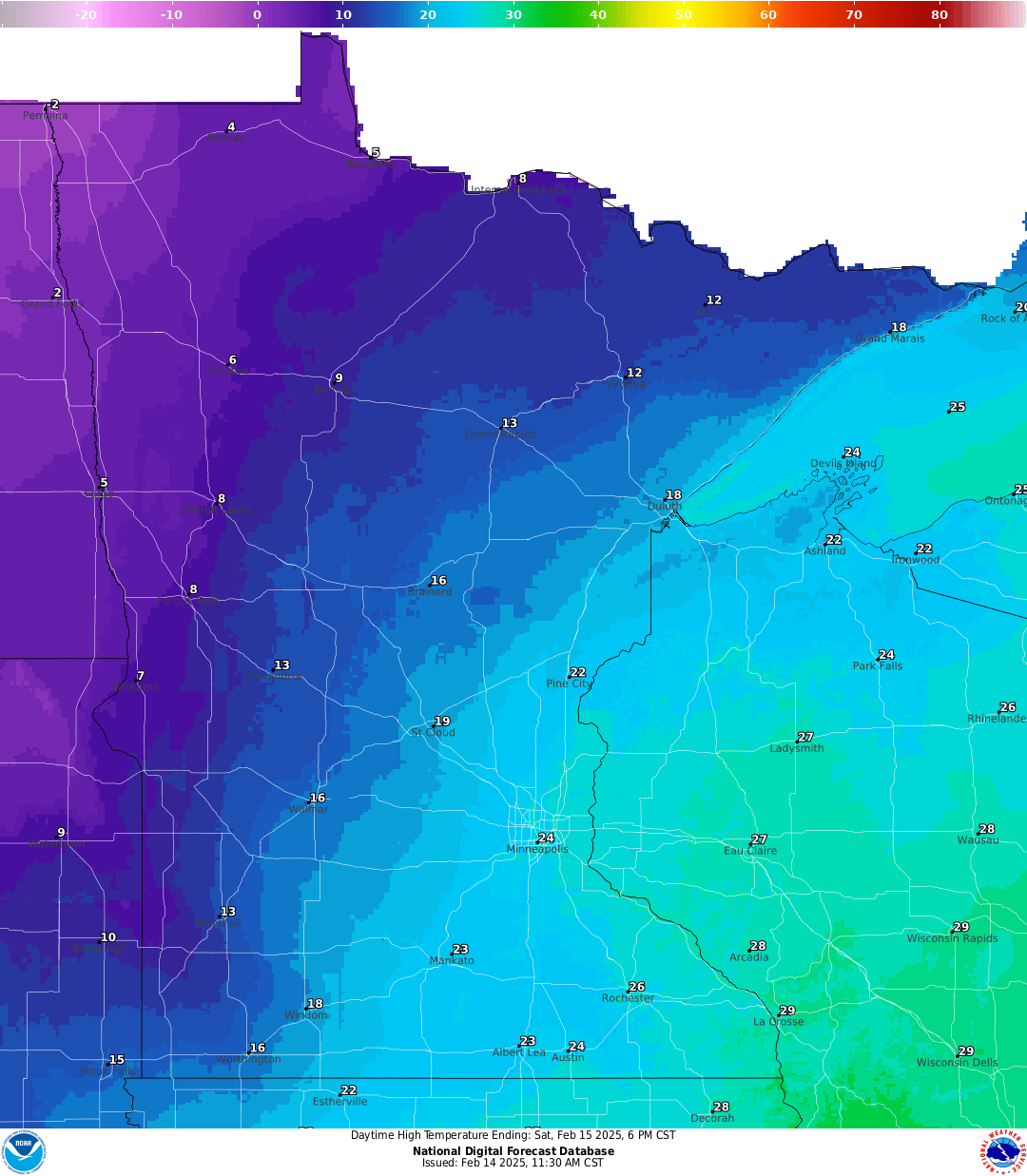
Valentine’s Day snowfall
“Life is like a box of chocolates, you never know what you’re gonna get.” — Forrest Gump
I’d swap the word “life” with “the forecast,” because sometimes the weather is just as unpredictable as life and Friday’s snowfall is no exception!
Our snowfall is still on track for the Twin Cities metro area, but it has a lot of dry air to get through first. As our chief meteorologist Paul Huttner put it yesterday, this is a boom or bust situation. There’s a significant amount of dry air overhead that the system needs to overcome before the snow can start falling. And right now, it’s not looking too promising for the Twin Cities metro area. The dry air is definitely putting a damper on things.
Turn Up Your Support
MPR News helps you turn down the noise and build shared understanding. Turn up your support for this public resource and keep trusted journalism accessible to all.
The National Weather Service is still forecasting 3-4 inches of snow for the metro. However, if the snow begins later than expected, we may only see about 1 inch or so. Southeastern Minnesota and central Wisconsin have a higher likelihood of seeing more than 4 inches of snow.

Winter weather advisories will be in effect from 2 p.m. Friday until 3 a.m. Saturday for the Twin Cities, as well as portions of eastern and southeastern Minnesota extending into Wisconsin.
According to the Weather Prediction Center's probability guide, there is a 50 to 70 percent chance that the metro area will receive more than 2 inches of snow.

Temperatures for Friday night will dip into the upper teens to low 20s in the Twin Cities and southeastward, while central and northern Minnesota will experience single digits, both above and below zero.

Saturday will bring temperatures closer to our seasonal average, with highs reaching the 20s. However, very cold arctic air will start moving into northwestern Minnesota, where highs are expected to only be in the single digits.
Saturday night, we'll have another shot at light snow, likely amounting to 1 inch or less.

Another wave of frigid arctic air is on the way for most of next week, bringing dangerously cold wind chills in the 30 to 40 degrees below zero range. Temperatures will be stuck in the single digits, both above and below zero.

My puppy Aspen wants to wish everybody a Happy Valentine’s Day! Stay warm!

