

Winter storm Wednesday takes aim at southern Minnesota
Midweek temperatures will also be cooler

Go Deeper.
Create an account or log in to save stories.
Like this?
Thanks for liking this story! We have added it to a list of your favorite stories.
Our active March weather continues. Enjoy a quiet day Tuesday, though it’ll be cooler. Wintry weather with heavy snow develops for Wednesday south and southeast.
Potential heavy snow for southern Minnesota Wednesday
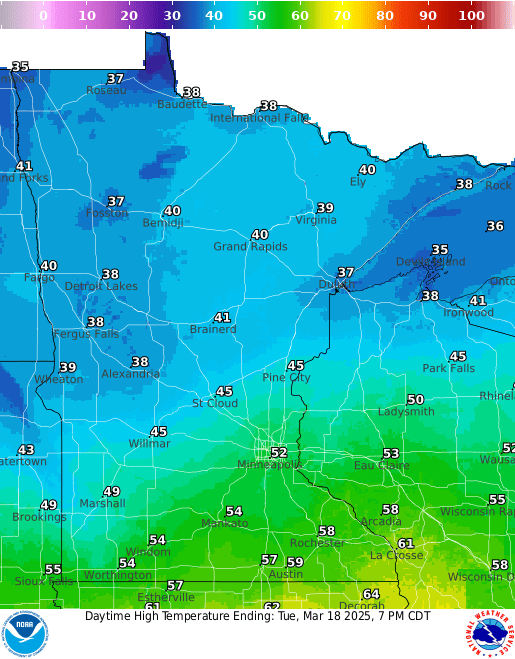
Cooler air is already settling into Minnesota, setting the stage for our next round of wintry weather. Highs Tuesday will still be in the low 50s for the Twin Cities and even near 60 degrees along the Minnesota-Iowa border. Northern Minnesota will in the upper 30s to low 40s.
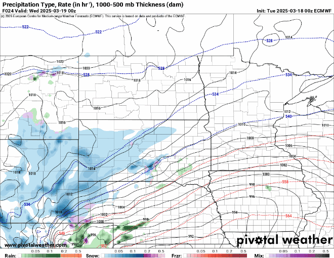
A few rain and snow showers are possible Tuesday afternoon and evening with the main action filling in late Tuesday night into early Wednesday.
Initially, the precipitation will be in the form of a rain and snow mix with pockets of freezing rain where temperatures are below freezing in southeastern Minnesota. The moisture quickly becomes all snow early Wednesday morning and will fall into the late afternoon.
Turn Up Your Support
MPR News helps you turn down the noise and build shared understanding. Turn up your support for this public resource and keep trusted journalism accessible to all.
The Twin Cities metro area will be on the northwestern edge of this system.
Blizzard warnings, winter storm watches and winter weather advisories are posted for much of south-central and southeastern Minnesota into western Wisconsin for Wednesday.
These could and likely will shift during Tuesday as the latest forecast models show a trend toward the southeast.

The heaviest snow will fall across south-central and southeastern Minnesota with easily more than 6 inches of snow looking increasingly likely. The big question is Twin Cities snowfall as we’ll be on the northwestern edge of a very tight snowfall gradient.

Morning forecast models are just updating and coming in and there is a noticeable trend to the southeast with the heaviest snowfall.
While there are a couple models that still paint significant snow in the southeast metro, most are shifting south. About half the forecast models now give Minneapolis-St. Paul proper one-half inch or less.

Stay tuned to forecasts Tuesday as they are likely to change through the day for Wednesday’s snowfall forecast.
Temperatures will be cooler Wednesday and Thursday as well, but they’ll move above freezing during the afternoons, leading to melting snow.
