

SE Minnesota blizzard footprint visible from space; weather volunteers needed
Ever wanted to be a trained weather observer? Now is your chance
Go Deeper.
Create an account or log in to save stories.
Like this?
Thanks for liking this story! We have added it to a list of your favorite stories.
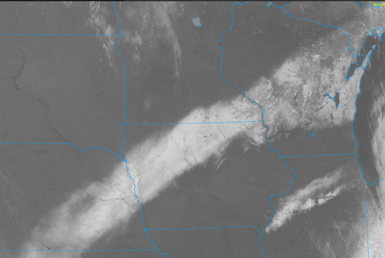
Wednesday’s blizzard left a mark across southeast Minnesota. Literally.
A stripe of snow on the ground left behind by the blizzard is visible from 23,000 miles above us via National Oceanic and Atmospheric Administration satellites. You can see the blizzard footprint in the GOES-16 1 km visible satellite image at the top of this post.
And look at how temperatures over the snow patch are 10 to 20 degrees colder than areas to the northwest!

That’s because the so called albedo of fresh snow reflects about 80 to 95 percent of incoming sunlight before it can hit the ground and heat the air above it. Cool stuff!
Turn Up Your Support
MPR News helps you turn down the noise and build shared understanding. Turn up your support for this public resource and keep trusted journalism accessible to all.

Here are some final impressive snowfall totals from Wednesday’s classic March blizzard:
Caledonia, 10 inches
Bricelyn, 9.5 inches
Spring Valley, 9 inches
Chatfield, 8.5 inches
Ridgeway (Winona County), 8 inches
Blue Earth, 8 inches
Austin 7, inches
Rochester, 6.3 inches
Albert Lea, 6 inches
Sunday snow chance
Turning to our weather forecast, southern Minnesota will enjoy a couple milder days before our weather takes another inclement March turn Sunday.
Highs Friday will reach well into the 50s in the south. But note the colder air sliding into the north once again.

Sunday’s weather system looks likely to dump significant snow across the northern half of Minnesota.
The Twin Cities could get a little slushy accumulation on the backside in the windy wraparound Sunday afternoon and evening. NOAA’s Global Forecast System model is pretty consistent with the European Centre for Medium-Range Weather Forecasts model solution as of Thursday:

Right now, I’m leaning toward 3 to 6 inches across northeastern Minnesota Sunday. Lake effect could dump more than 6 inches along and above the North Shore.
Stay tuned for updates the next couple days.
Weather observers wanted!
Have you ever wanted to become a trained weather observer? There are hundreds of people across our region who contribute rain and other precipitation reports to the Community Collaborative Rain, Hail and Snow Network.

The are looking for observes especially in greater Minnesota outside the Twin Cities area. Here’s more from the Minnesota State Climatology Office:
The Minnesota Department of Natural Resources’ State Climatology Office is seeking rainfall monitors for the Community Collaborative Rain, Hail and Snow Network. The network includes more than 20,000 volunteers nationwide who measure precipitation in their backyards using a standard 4-inch diameter rain gauge.
Participants submit their precipitation reports online. The data from backyard rain gauges are a critical source of information and it’s beneficial to add more volunteer weather observers each year, even in areas where there are already volunteers.
“Rainfall and snowfall amounts can vary widely over a short distance, so a variety of reports is helpful in the same community or area,” State Climatologist Luigi Romolo said. “We have some areas in greater Minnesota that have very few reporting stations. The more we have across the state, the better information we all have.”
Volunteers are particularly needed outside the immediate Twin Cities metro area. Volunteers receive training on how to observe weather trends and how to submit their precipitation and weather event reports. All training material is available online. Participants must purchase or provide a standard 4-inch diameter rain gauge (available at discount through CoCoRaHS) and have internet access to submit reports.
“Over time, as more volunteer reports make our precipitation maps more accurate, these observations provide critical guidance on Minnesota’s changing climate,” Romolo said. “This is also a great educational activity for families with kids and a rewarding hobby for anyone interested in weather or climate.”
For the past five years, Minnesota has won the “CoCoRaHS Cup” for recruiting the most new volunteers of any state during the March national recruiting drive.
“Year after year, Minnesotans are the best in the nation at stepping up and joining this important effort. Let’s keep the cup in Minnesota as we continue to improve our state’s precipitation recording,” Romolo said.
To sign up or for more information, visit the CoCoRaHS website opens in a new browser tab or contact Luigi Romolo opens in a new browser tab.
Join the fun!
