

Sunshine returns Tuesday and Wednesday! Next rain chance arrives Thursday
A bit milder through midweek.

Go Deeper.
Create an account or log in to save stories.
Like this?
Thanks for liking this story! We have added it to a list of your favorite stories.
It’s a weather roller coaster ride this week across Minnesota. Our gray blustery Monday whipped up wind gusts over 40 mph and scattered showers across most of Minnesota.
Our weather turns for the sunnier Tuesday and Wednesday. NOAA’s FV3 model low cloud output shows abundant sunshine with far fewer clouds across Minnesota between 7 a.m. Tuesday and 7 p.m. Wednesday.

Tuesday will still be breezy with gusts to 25 mph, but the wind will not be as feisty as Monday. Highs will be mostly in the 50s south and 40s north Tuesday.

Wednesday will be the nicest day of the week overall with plentiful sunshine and light winds. Highs in the 60s will cover most of southern Minnesota.
Turn Up Your Support
MPR News helps you turn down the noise and build shared understanding. Turn up your support for this public resource and keep trusted journalism accessible to all.

Thursday brings additional warmth ahead of our next rain system.
Next rain Thursday
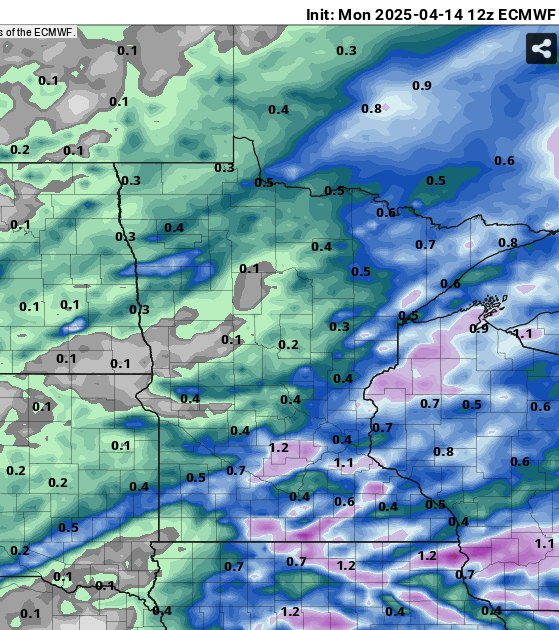
A pretty nice low pressure system will spin into Minnesota Thursday. The Canadian model output shows rain and possible thunderstorms moving in. The loop below runs between 7 a.m. Thursday and 1 a.m. Friday.

Early indications suggest rainfall totals between one half and one inch with Thursday’s system.
Right now the weekend looks sunny on Saturday but another rain system is possible by Sunday.
