Flood picture in Twin Cities complicated by storm forecast
Go Deeper.
Create an account or log in to save stories.
Like this?
Thanks for liking this story! We have added it to a list of your favorite stories.

The National Weather Service has been warning for weeks that spring flooding in Minnesota could be bad. It's just been a question of how bad.
The agency now says the answer may become clear over the next few days as a storm system moves in to the area bringing possible rain and snow.
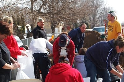
Shelly Rowedder is worried. She was leading a group of about 30 people on Saturday morning who had improvised a sandbag assembly line in a neighborhood next to the Mississippi River in Newport, just south of St. Paul.
They were hauling sand, filling sandbags, and carefully placing them to form a wall around a gray one-story home that sits one street away from the river.
Turn Up Your Support
MPR News helps you turn down the noise and build shared understanding. Turn up your support for this public resource and keep trusted journalism accessible to all.
"I got a message from a friend saying the river's coming up and she needs as much help as she can," Rowedder said. "So all of her friends showed up and here we are."
Rowedder had a sheen of sweat on her forehead. She squinted into the bright sunshine and shook her head, looking at the inactive homes around her.
"If I were these neighbors I'd be concerned," she said. "They just dropped off the sand two days ago, so maybe they're just a little behind."
Officials have found that a levee in the area to be inadequate in the event of a flood, which may be coming soon.

But on late Saturday morning the neighborhood had a sleepy feel. Activity bustled outside just one house.
Even after the rains on Saturday night and Sunday morning, there was little sign of activity in towns that are forecast to be hard hit.
In South St. Paul, another town with a levee the Army Corps of Engineers has deemed inadequate, officials said everything that could be done at this point had been done.
Things were quiet in Jordan, a town southwest of the metro where officials have been worried about frozen chunks of ice on Sand Creek, which runs through downtown. Ice jams could cause water to back up and spill onto frontage roads near a mobile-home park.
But on Sunday, Sand Creek was rushing low on its banks; city officials said the ice chunks had passed and the waterway is stable.
It's the calm before the storm. And it won't last long, according to National Weather Service hydrologist Diane Cooper.
"We're continuing to monitor the situation with the system anticipated Tuesday and into Wednesday," Cooper said.
Cooper said a large system moving into the area will likely bring rain late Tuesday, changing to snow on Wednesday. But she isn't sure exactly how much precipitation there's going to be — or where it's going to fall.
Cooper said the only thing she knows for sure is that more precipitation will heighten the flood risk.
"Everywhere is highly sensitive at this point," Cooper said.
That's a message officials in St. Paul have heard loud and clear. The National Weather Service has given the city an 80 percent chance of reaching 2001 flood levels of about 23 feet. The agency says the Mississippi River at St. Paul could reach flood stage, 14 feet, by Thursday, rising to 18 feet by Sunday.
St. Paul on Monday closes down Shepard Road from Eagle Street to Highway 61 to start construction on a levee.
City Emergency Management Director Rick Larkin said the extent of preparations depends on how much precipitation falls this week and what form it takes. Snow means it'll take longer to melt, longer to reach rivers and longer to flood. Rain means it all happens sooner.
"I'm a little bit done with winter myself, but I would prefer snow and I would prefer cold nights," Larkin said, adding that 40s during the day would allow for a more controlled melt.
"It gives us a little bit easier rise on the river levels, but this moisture entering the river system is really a large unknown," Larkin said.
Larkin said the city must prepare even when it doesn't have all the information.
Dear reader,
The trustworthy and factual news you find here at MPR News relies on the generosity of readers like you.
Your donation ensures that our journalism remains available to all, connecting communities and facilitating better conversations for everyone.
Will you make a gift today to help keep this trusted new source accessible to all?


